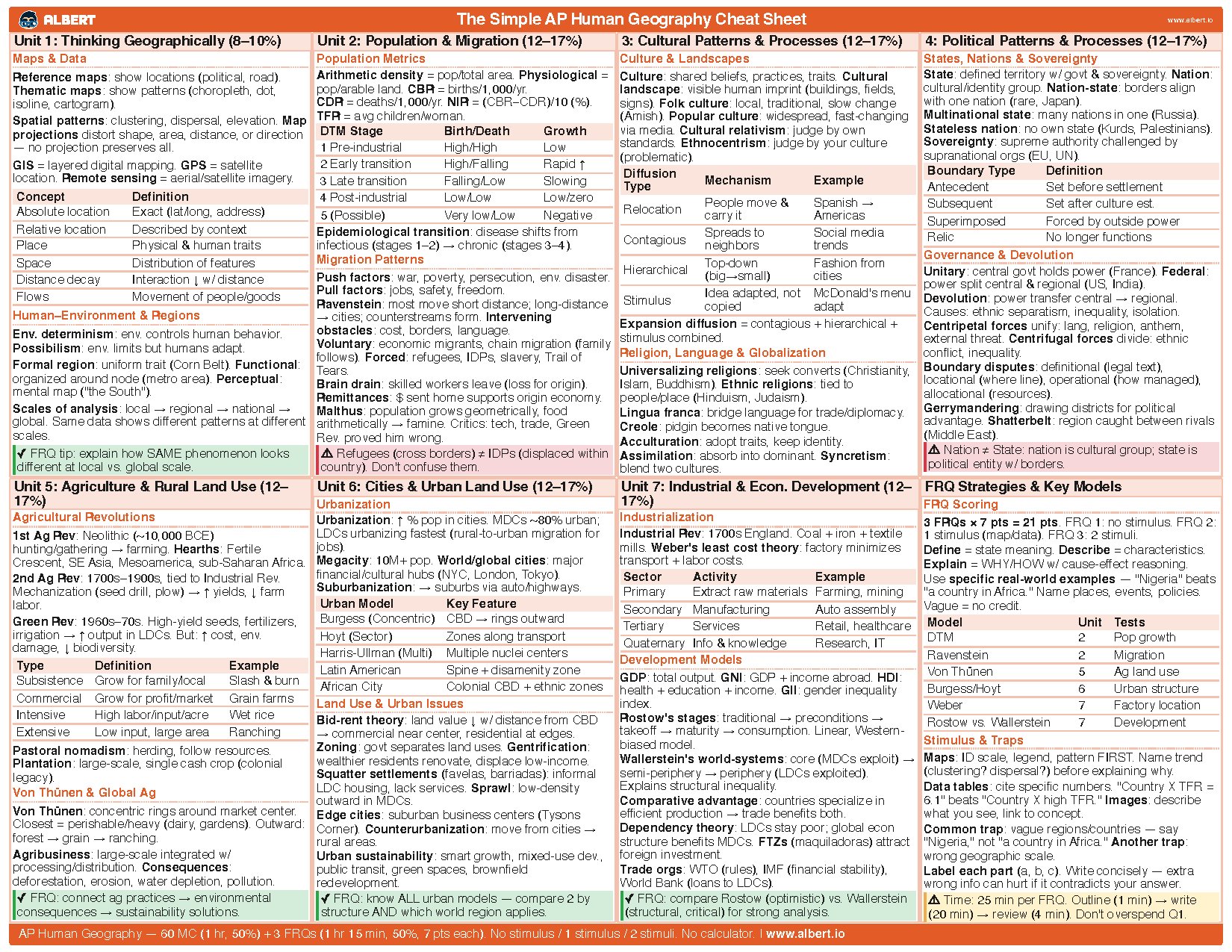
The Simple AP Human Geography Cheat Sheet
Unit 1: Thinking Geographically (8–10%)
Maps & Data
Reference maps: show locations (political, road).
Thematic maps: show patterns (choropleth, dot,
isoline, cartogram).
Spatial patterns: clustering, dispersal, elevation. Map
projections distort shape, area, distance, or direction
— no projection preserves all.
GIS = layered digital mapping. GPS = satellite
location. Remote sensing = aerial/satellite imagery.
Concept Definition
Absolute location Exact (lat/long, address)
Relative location Described by context
Place Physical & human traits
Space Distribution of features
Distance decay Interaction ↓ w/ distance
Flows Movement of people/goods
Human–Environment & Regions
Env. determinism: env. controls human behavior.
Possibilism: env. limits but humans adapt.
Formal region: uniform trait (Corn Belt). Functional:
organized around node (metro area). Perceptual:
mental map ("the South").
Scales of analysis: local → regional → national →
global. Same data shows different patterns at different
scales.
✓
FRQ tip: explain how SAME phenomenon looks
different at local vs. global scale.
Unit 2: Population & Migration (12–17%)
Population Metrics
Arithmetic density = pop/total area. Physiological =
pop/arable land. CBR = births/1,000/yr.
CDR = deaths/1,000/yr. NIR = (CBR−CDR)/10 (%).
TFR = avg children/woman.
DTM Stage Birth/Death Growth
1 Pre-industrial High/High Low
2 Early transition High/Falling Rapid ↑
3 Late transition Falling/Low Slowing
4 Post-industrial Low/Low Low/zero
5 (Possible) Very low/Low Negative
Epidemiological transition: disease shifts from
infectious (stages 1–2) → chronic (stages 3–4).
Migration Patterns
Push factors: war, poverty, persecution, env. disaster.
Pull factors: jobs, safety, freedom.
Ravenstein: most move short distance; long-distance
→ cities; counterstreams form. Intervening
obstacles: cost, borders, language.
Voluntary: economic migrants, chain migration (family
follows). Forced: refugees, IDPs, slavery, Trail of
Tears.
Brain drain: skilled workers leave (loss for origin).
Remittances: $ sent home supports origin economy.
Malthus: population grows geometrically, food
arithmetically → famine. Critics: tech, trade, Green
Rev. proved him wrong.
⚠
Refugees (cross borders) ≠ IDPs (displaced within
country). Don't confuse them.
3: Cultural Patterns & Processes (12–17%)
Culture & Landscapes
Culture: shared beliefs, practices, traits. Cultural
landscape: visible human imprint (buildings, fields,
signs).Folk culture: local, traditional, slow change
(Amish). Popular culture: widespread, fast-changing
via media.Cultural relativism: judge by own
standards. Ethnocentrism: judge by your culture
(problematic).
Diffusion
Type
Mechanism Example
Relocation
People move &
carry it
Spanish →
Americas
Contagious
Spreads to
neighbors
Social media
trends
Hierarchical
Top-down
(big→small)
Fashion from
cities
Stimulus
Idea adapted, not
copied
McDonald's menu
adapt
Expansion diffusion = contagious + hierarchical +
stimulus combined.
Religion, Language & Globalization
Universalizing religions: seek converts (Christianity,
Islam, Buddhism). Ethnic religions: tied to
people/place (Hinduism, Judaism).
Lingua franca: bridge language for trade/diplomacy.
Creole: pidgin becomes native tongue.
Acculturation: adopt traits, keep identity.
Assimilation: absorb into dominant. Syncretism:
blend two cultures.
4: Political Patterns & Processes (12–17%)
States, Nations & Sovereignty
State: defined territory w/ govt & sovereignty. Nation:
cultural/identity group. Nation-state: borders align
with one nation (rare, Japan).
Multinational state: many nations in one (Russia).
Stateless nation: no own state (Kurds, Palestinians).
Sovereignty: supreme authority challenged by
supranational orgs (EU, UN).
Boundary Type Definition
Antecedent Set before settlement
Subsequent Set after culture est.
Superimposed Forced by outside power
Relic No longer functions
Governance & Devolution
Unitary: central govt holds power (France). Federal:
power split central & regional (US, India).
Devolution: power transfer central → regional.
Causes: ethnic separatism, inequality, isolation.
Centripetal forces unify: lang, religion, anthem,
external threat. Centrifugal forces divide: ethnic
conflict, inequality.
Boundary disputes: definitional (legal text),
locational (where line), operational (how managed),
allocational (resources).
Gerrymandering: drawing districts for political
advantage. Shatterbelt: region caught between rivals
(Middle East).
⚠
Nation ≠ State: nation is cultural group; state is
political entity w/ borders.
Unit 5: Agriculture & Rural Land Use (12–
17%)
Agricultural Revolutions
1st Ag Rev: Neolithic (~10,000 BCE)
hunting/gathering → farming. Hearths: Fertile
Crescent, SE Asia, Mesoamerica, sub-Saharan Africa.
2nd Ag Rev: 1700s–1900s, tied to Industrial Rev.
Mechanization (seed drill, plow) → ↑ yields, ↓ farm
labor.
Green Rev: 1960s–70s. High-yield seeds, fertilizers,
irrigation → ↑ output in LDCs. But: ↑ cost, env.
damage, ↓ biodiversity.
Type Definition Example
Subsistence Grow for family/local Slash & burn
Commercial Grow for profit/market Grain farms
Intensive High labor/input/acre Wet rice
Extensive Low input, large area Ranching
Pastoral nomadism: herding, follow resources.
Plantation: large-scale, single cash crop (colonial
legacy).
Von Thünen & Global Ag
Von Thünen: concentric rings around market center.
Closest = perishable/heavy (dairy, gardens). Outward:
forest → grain → ranching.
Agribusiness: large-scale integrated w/
processing/distribution. Consequences:
deforestation, erosion, water depletion, pollution.
✓
FRQ: connect ag practices → environmental
consequences → sustainability solutions.
Unit 6: Cities & Urban Land Use (12–17%)
Urbanization
Urbanization: ↑ % pop in cities. MDCs ~80% urban;
LDCs urbanizing fastest (rural-to-urban migration for
jobs).
Megacity: 10M+ pop. World/global cities: major
financial/cultural hubs (NYC, London, Tokyo).
Suburbanization: → suburbs via auto/highways.
Urban Model Key Feature
Burgess (Concentric) CBD → rings outward
Hoyt (Sector) Zones along transport
Harris-Ullman (Multi) Multiple nuclei centers
Latin American Spine + disamenity zone
African City Colonial CBD + ethnic zones
Land Use & Urban Issues
Bid-rent theory: land value ↓ w/ distance from CBD
→ commercial near center, residential at edges.
Zoning: govt separates land uses. Gentrification:
wealthier residents renovate, displace low-income.
Squatter settlements (favelas, barriadas): informal
LDC housing, lack services. Sprawl: low-density
outward in MDCs.
Edge cities: suburban business centers (Tysons
Corner). Counterurbanization: move from cities →
rural areas.
Urban sustainability: smart growth, mixed-use dev.,
public transit, green spaces, brownfield
redevelopment.
✓
FRQ: know ALL urban models — compare 2 by
structure AND which world region applies.
Unit 7: Industrial & Econ. Development (12–
17%)
Industrialization
Industrial Rev: 1700s England. Coal + iron + textile
mills. Weber's least cost theory: factory minimizes
transport + labor costs.
Sector Activity Example
Primary Extract raw materials Farming, mining
Secondary Manufacturing Auto assembly
Tertiary Services Retail, healthcare
Quaternary Info & knowledge Research, IT
Development Models
GDP: total output. GNI: GDP + income abroad. HDI:
health + education + income. GII: gender inequality
index.
Rostow's stages: traditional → preconditions →
takeoff → maturity → consumption. Linear, Western-
biased model.
Wallerstein's world-systems: core (MDCs exploit) →
semi-periphery → periphery (LDCs exploited).
Explains structural inequality.
Comparative advantage: countries specialize in
efficient production → trade benefits both.
Dependency theory: LDCs stay poor; global econ
structure benefits MDCs. FTZs (maquiladoras) attract
foreign investment.
Trade orgs: WTO (rules), IMF (financial stability),
World Bank (loans to LDCs).
✓
FRQ: compare Rostow (optimistic) vs. Wallerstein
(structural, critical) for strong analysis.
FRQ Strategies & Key Models
FRQ Scoring
3 FRQs × 7 pts = 21 pts. FRQ 1: no stimulus. FRQ 2:
1 stimulus (map/data). FRQ 3: 2 stimuli.
Define = state meaning. Describe = characteristics.
Explain = WHY/HOW w/ cause-effect reasoning.
Use specific real-world examples — "Nigeria" beats
"a country in Africa." Name places, events, policies.
Vague = no credit.
Model Unit Tests
DTM 2 Pop growth
Ravenstein 2 Migration
Von Thünen 5 Ag land use
Burgess/Hoyt 6 Urban structure
Weber 7 Factory location
Rostow vs. Wallerstein 7 Development
Stimulus & Traps
Maps: ID scale, legend, pattern FIRST. Name trend
(clustering? dispersal?) before explaining why.
Data tables: cite specific numbers. "Country X TFR =
6.1" beats "Country X high TFR." Images: describe
what you see, link to concept.
Common trap: vague regions/countries — say
"Nigeria," not "a country in Africa." Another trap:
wrong geographic scale.
Label each part (a, b, c). Write concisely — extra
wrong info can hurt if it contradicts your answer.
⚠
Time: 25 min per FRQ. Outline (1 min) → write
(20 min) → review (4 min). Don't overspend Q1.
AP Human Geography — 60 MC (1 hr, 50%) + 3 FRQs (1 hr 15 min, 50%, 7 pts each). No stimulus / 1 stimulus / 2 stimuli. No calculator. | www.albert.io